Moab
is our first stop in Utah. We will spend
four nights in this area visiting Arches National Park, Canyonlands National
Park, and Dead Horse Point State Park.

April 20 – 23: We stayed at the Portal RV Resort in Moab, Utah. This was a small RV park with only about 46
sites. We were surrounded by nice views
of tall red cliffs and rocks. There
was a section of this park where you purchase the sites for either your trailer
or a condo. The guests in the RV section
were not allowed in this area. It was
fenced off with many signs. Very
unfriendly. But we had a nice spacious site
and it was quiet.


Time to eat! Like clockwork, they
patiently wait at @ 5pm, even when we cross time zones.
MOAB is the place to stay for
adventures. It’s the starting point for
four-wheel drives, white-water rafting, cross-country skiing, hiking, horseback
and mountain biking trips. It is tucked
in a valley at the foot of red cliffs and the La Sal Mountains. There are many shops in town that offer tours
and equipment for these adventures. There
are a few nice restaurants in town. And
of course shops with red rock souvenirs and sports clothing, etc. We did not have time to shop, but we had time
for food. We found two nice restaurants
to have dinner and lunch.


Peace Tree Café. This is a funky, colorful place

Lunch was delicious & peaceful. i

ARCHES
NATIONAL PARK
Five
miles northwest of Moab is Arches National Park. This NP contains the largest number of
natural stone arches in the country. Along
with 2,000 arches, there are many red rock canyons, spires, fins and balancing
rocks. Here a some of the many pictures
we took.


Balanced Rock


Double Arch


I see a turtle!


Delicate Arch


I call these Pancake Rocks


Shadow Selfie

Sanddune Arch
DEAD HORSE
POINT STATE PARK
Ten
miles west of Moab is Dead Horse Point State Park. Dead Horse Point towers 2,000 feet above the
Colorado River with views of the pinnacles and buttes of the Island in the Sky
District of Canyonlands National Park.
There are a few stories on the name.
One is a band of wild mustangs was once herded into a natural corral
formed by the rock formations and were forgotten about. They were left there to die of thirst, in
view of the Colorado River. A sad story,
but that explains the name.


Rim Trail


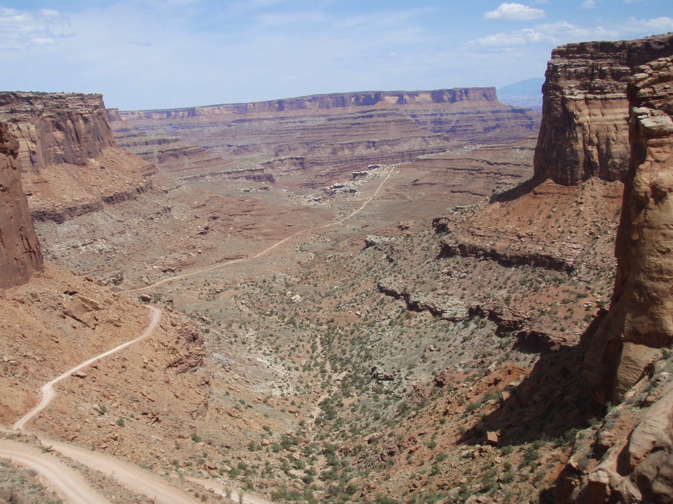
See that dirt road in the above and below pictures? That is Potash and then Shafer Road. It stems off of Hwy 279 and ends at the mesa top of Canyonlands National Park. We will be traveling that road on the next day.


Colorado River
HIGHWAY 279
Highway 279 leads onto
Potash Road which is on land owned by Moab Salt LLC. Potash Road is a dirt, gravel, rocky and
winding road that takes you across the canyon and between the red rocks to
Shafer Basin and Road. Shafer Road
switchbacks up to the mesa top to Canyonlands National Park. It is one of four ways to get into Canyonlands. It is the daring and adventurous way and one
of the most beautiful and scenic routes into this National Park. This route is
about 20 miles long. It took us more than 2 hours to travel it. 
We traveled circled area.

Highway 279 h

Potash Road h

Moab Salt LLC land h


Solar Evaporation Ponds h

Potash Road continues


Potash Road now becomes Shafer Road


That’s Canyonlands NP ahead. h

Colorado River h

Shafer Road continues

We are now entering the NP


Almost there – looking down
Still Shafer road

Made it to the top!!

That was an adventure!

CANYONLANDS
NATIONAL PARK
Canyonlands
National Park encompasses deeply eroded canyons with sheer-sided mesas and a
variety of spires, arches and unusual rock formations. The park is divided into three districts,
each entered into by different roads. The
Needles District is at the south eastern end of the park and that entrance road
at least 100 miles out of our way. That
will be another day on another trip. The
Maze District is at the south western part of the park and that is a rough dirt
road and definitely needs a 4-wheel drive.
We visited the “Island in the Sky” area in the north eastern part of the
park. There are two ways to get into
this area. We took the adventurous route.


Grand View Overlook


Green River Overlook
The
Green and Colorado rivers join in the middle of Canyonlands. The only way to see this joining is by hiking
to it.
Our
next stop is GOULDINGS, UT where we will visit MONUMENT VALLEY, NATURAL BRIDGES NATIONAL PARK
and a few state parks.
No comments:
Post a Comment